“เสียมกุก” ชาวสยามจากแอ่งสกลนคร ศูนย์กลางที่ “เวียงจันทน์”
“เสียมกุก” ชาวสยามจากแอ่งสกลนคร ศูนย์กลางที่ “เวียงจันทน์”
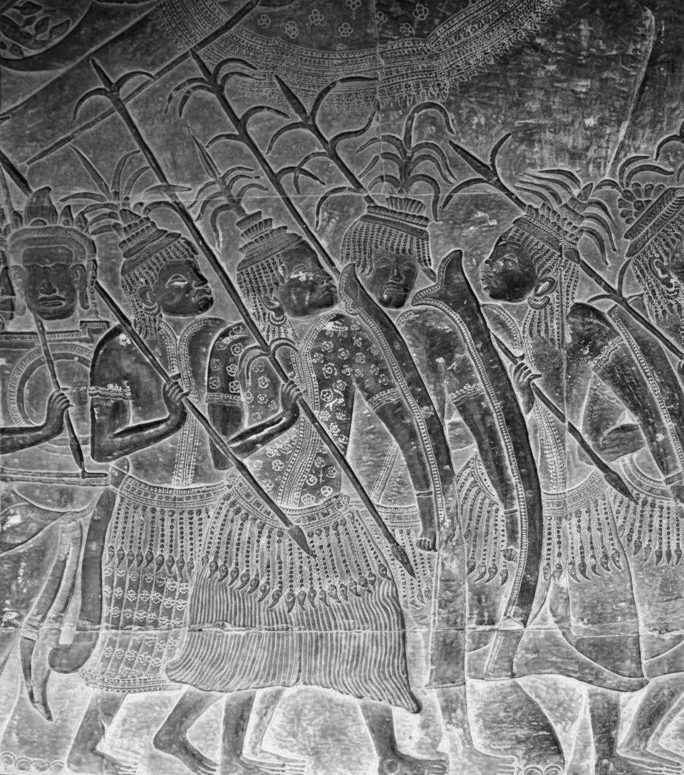
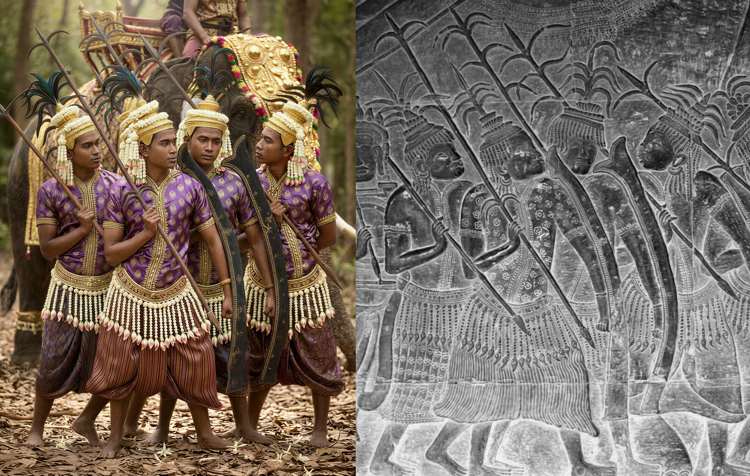
ภาพที่ผ่านการบูรณะและสร้างสรรค์ด้วยเทคโนโลยี AI นี้ เป็นภาพของ “เสียมกุก” คือชาวสยามที่ปรากฏอยู่บนภาพสลักระเบียงประวัติศาสตร์ หรือระเบียงคดของปราสาทนครวัด
“เสียมกุก” คือชาวสยามที่ปรากฏอยู่บนภาพสลักระเบียงประวัติศาสตร์ หรือระเบียงคดของปราสาทนครวัด เป็นข้อความว่า “เนะ สยำ กุก” อันแปลความได้ว่า “นี่(ไง) พวกสยาม” เพราะ “สยำ” คือเสียมหรือสยาม ส่วน “กุก” สันนิษฐานว่ารับอิทธิพลจากภาษาจีน คือ “ก๊ก” หมายถึง พวก หมู่ เหล่า ชาว ฯลฯ
ภาพสลัก “เสียมกุก” โด่งดังอย่างมากในแวดวงนักวิชาการประวัติศาสตร์และผู้สนใจทั้งหลาย ในฐานะหลักฐานการมีอยู่ของชนชาติสยาม บนโบราณสถานอันยิ่งใหญ่ของอารยธรรมเขมรโบราณ ณ เมืองพระนคร (นครวัด) หรือพระบรมวิษณุโลก
หากว่ากันด้วยหลักฐานเชิงประจักษ์ ภาพสลัก เสียมกุก คือสัญลักษณ์ขบวนเกียรติยศของกลุ่มเครือญาติ พระเจ้าสุริยวรมันที่ 2 ระหว่างพิธีกรรมสำคัญบางอย่าง ซึ่งอาจเป็นพิธีบรมราชาภิเษก หรือพิธีสถาปนาเป็นพระวิษณุสถิตบรมวิษณุโลก เท่ากับว่า “ชาวเสียม” หรือชาวสยาม ย่อมต้องเป็นเครือญาติใกล้ชิดของกษัตริย์เขมรโบราณพระองค์นี้ เช่นเดียวกับขบวนทัพของพวกละโว้ และพิมาย ที่ปรากฏเป็นขบวนพยุหยาตราเรียงรายอยู่บนระเบียงคดด้วยเช่นกัน ซึ่งดินแดนเหล่านี้ล้วนเป็นเครือญาติกับกษัตริย์เขมรแห่งเมืองพระนครทั้งสิ้น
สุจิตต์ วงษ์เทศ อธิบายว่า “สยาม มีรากจากคำพื้นเมืองบริเวณลุ่มน้ำสาละวิน-ลุ่มน้ำโขง ว่า ซำ หรือ ซัม หมายถึง พื้นที่มีน้ำพุ หรือน้ำผุดจากใต้ดิน ซึ่งบางท้องถิ่นเรียกน้ำซับน้ำซึม ครั้นนานปี (หรือนานเข้า) น้ำเหล่านั้นไหลนองเป็นหนองหรือบึงขนาดน้อยใหญ่ กลายเป็นแหล่งปลูกข้าว ในที่สุดทำนาทดน้ำ ผลิตข้าวได้มากไว้เลี้ยงคนจำนวนมาก ทำให้ชุมชนหมู่บ้านเริ่มแรกเมื่อติดต่อชุมชนห่างไกลก็เติบโตเป็นเมือง, รัฐ, อาณาจักร”
“สยาม เป็นชื่อดินแดน ที่คนพวกอื่นซึ่งอยู่ภายนอกใช้เรียกบริเวณลุ่มน้ำเจ้าพระยา และลุ่มน้ำโขงตอนบนอย่างกว้าง ๆ หลวม ๆ … สยามไม่ใช่ชื่อชาติพันธุ์หนึ่งใดโดยเฉพาะ แต่ใช้เรียกกลุ่มคนที่อยู่ดินแดนสยามว่า ‘ชาวสยาม’ โดยไม่จำกัดชาติพันธุ์หรือชาติภาษา แต่มักสื่อสารกันทั่วไปด้วยตระกูลภาษาไทย-ลาว ซึ่งเป็นภาษากลางทางการค้าภายในสมัยโบราณ”
แม้ความเชื่อที่ว่า เสียมกุก คือชาวสยามและบรรพบุรุษสาขาหนึ่งของคนไทยนั้นค่อนข้างเป็นเอกฉันท์ แต่คำอธิบายเชิงว่าด้วย “ตัวตน” ที่แท้จริงของพวกเขาว่าเป็นคนกลุ่มไหน หลักแหล่งแห่งที่คือบริเวณใดของประเทศไทย หรืออุษาคเนย์ ประเด็นนี้ยังถูกย่อยออกเป็นหลายทิศทาง
นักวิชาการตะวันตกเชื่อว่าเสียมกุกคือกองทัพสยามจากรัฐสุโขทัย ส่วน จิตร ภูมิศักดิ์ เสนอว่า เป็นชาวสยามแห่งลุ่มน้ำกก บริเวณจังหวัดเชียงราย ขณะที่เอกสารจีนเองเรียกผู้คนในแคว้นสุพรรณภูมิ (สุพรรณบุรี) ว่าพวก “เสียน” หรือ “เสียม” เช่นกัน อย่างไรก็ตาม มีความไม่สอดคล้องบางประการในแนวคิดเหล่านี้ เพราะกลางพุทธศตวรรษที่ 17 หรือช่วงเวลาที่เกิดภาพสลัก “เสียมกุก” บนระเบียงประวัติศาสตร์นั้น ทั้งสุโขทัย ดินแดนลุ่มน้ำกก และแคว้นสุพรรณภูมิ ยังไม่ใช่บ้านเมืองใหญ่โตหรือรัฐขนาดใหญ่ โดยเฉพาะรัฐสุโขทัย ซึ่งเพิ่งมาสถาปนาหลังจากนั้นเกือบ 100 ปี
เสียมกุก ชาวสยามจากลุ่มน้ำโขง
สุจิตต์ วงษ์เทศ เสนอว่า เสียมกุก คือชาวสยามจากแคว้นศรีโคตรบูร บริเวณแอ่งสกลนคร และมีศูนย์กลางอยู่ที่เวียงจันทน์ (ต้นฉบับสะกด “เวียงจัน”)
เป็นไปได้ว่าชาวสยามจากดินแดนนี้คือเครือญาติกษัตริย์เขมรแห่งเมืองพระนคร โดยเป็นกองทัพจากกลุ่มเมืองอีสานเหนือ “เวียงจัน-ศรีเชียงใหม่” ซึ่งรับวัฒนธรรมทวารวดีจากลุ่มแม่น้ำเจ้าพระยามาตั้งแต่โบราณกาลแล้ว ความเจริญดังกล่าวขยายขึ้นไปถึงแอ่งสกลนครและสองฟากแม่น้ำโขง ทำให้บริเวณเวียงจันทน์กับอำเภอศรีเชียงใหม่ (จังหวัดหนองคาย) มีเมืองโบราณขนาดใหญ่อยู่สองฝั่งแม่น้ำโขง ซึ่งเก่าแก่ราวพุทธศตวรรษที่ 14
เวียงจัน-ศรีเชียงใหม่ จึงมีลักษณะเป็นเมืองอกแตก (แม่น้ำโขงผ่ากลางเมือง) รูปร่างไม่สม่ำเสมอแบบเมืองสมัยทวารวดีทั่วไป การตรวจสอบทางโบราณคดีพบรอยคูน้ำคันดินชัดเจนบางตอน ขณะที่ฝั่งอำเภอศรีเชียงใหม่ลบเลือนไปหมดแล้ว แต่มีหลักฐานสำคัญคือศิลปกรรมแบบทวารวดีที่พบได้ทั่วทั้งสองฟากแม่น้ำโขง และหลักฐานจากเอกสารจีนที่กล่าวถึงเมืองสำคัญแห่งหนึ่ง ชื่อ “เหวินถาน” หรือ เวินตาน (Wen Tan) อยู่ในลุ่มแม่น้ำโขงตรงตำแหน่งที่เป็นเวียงจันทน์ในปัจจุบัน ทำให้เชื่อได้ว่า บริเวณนี้มีบ้านเมืองมาตั้งแต่ยุคเจนละ หรือก่อนอาณาจักรเขมรสมัยพระนครแล้ว
นักวิชาการจีนหลายคนเชื่อว่า เหวินถาน ก็คือ ว่านเซี่ยง หรือเมืองเวียงจันทน์ เมืองสำคัญที่เคยติดต่อกับราชสำนักจีนอยู่บ่อยครั้ง
อาจารย์ศรีศักร วัลลิโภดม อธิบายว่า เมืองเวียงจันทน์ มีกำเนิดและพัฒนาการขึ้นพร้อมบ้านเมืองในแอ่งสกลนคร คือบริเวณจังหวัดหนองคาย อุดรธานี นครพนม และสกลนคร อีกนัยหนึ่งคือ มีบ้านเมืองบริเวณสองฟากแม่น้ำโขงบริเวณแอ่งสกลนครมาก่อนลาวล้านช้างจะเคลื่อนย้ายลงมาจากทางเหนือ บริเวณนี้เองเป็นสถานที่ตั้งของแคว้นศรีโคตรบูร
ตำนานอุรังคธาตุ ระบุว่า แคว้นศรีโคตรบูรมีเมืองสำคัญอยู่บริเวณเมืองมรุกขนคร หรือนครพนม และเมืองหนองหานหลวง หรือสกลนคร ภายหลังจึงโยกย้ายไปสถาปนาศูนย์กลางแห่งใหม่ที่เวียงจันทน์ สอดคล้องกับร่อยรอยที่ปรากฏอยู่ในพงศาวดารเหนือ เรื่อง พระยาโคตรบอง
สุจิตต์ วงษ์เทศ ชี้ว่า “เมืองเวียงจันสมัยศรีโคตรบูร คือแว่นแคว้นของชาวเสียม หรือสยาม ที่พัฒนาขึ้นในระยะแรก ๆ เมื่อประมาณพุทธศตวรรษที่ 14-15 ในสองฟากแม่น้ำโขงของแอ่งสกลนคร ต่อมามีการขยายตัวอย่างใหญ่โตในพุทธศตวรรษที่ 16-17 จึงมีชื่อชาวเสียมหรือ สยาม ในจารึกจามและกัมพูชา โดยเฉพาะ จารึก ‘สยำ กุก’ หรือ “กองทัพสยาม” ที่ระเบียงประวัติศาสตร์ของปราสาทนครวัด คือกองทัพของชาวสยามจากเวียงจัน ชาวสยามจากแคว้นศรีโคตรบูรที่แอ่งสกลนครนี่แหละ ที่ไปสถาปนาแคว้นสุโขทัย”
ข้อสังเกตอีกประการจากภาพสลัก “เสียมกุก” คือการนุ่งผ้าโสร่งแบบให้เชิงผ้าด้านล่างผายเล็กน้อย เป็นผ้านุ่งแบบ “ผู้ไท” ซึ่งเป็นชาติพันธุ์ที่พูดภาษาไทย-ลาว และนับเป็นชาวสยามสาขาหนึ่งของพื้นที่แถบนี้ ชาวผู้ไทกระจายตัวอยู่ตลอดแนวเส้นทางการค้าของดินแดนภายในจากลุ่มแม่น้ำแดง-ดำในเวียดนาม ถึงลุ่มน้ำโขง
ชาวสยามแห่งลุ่มน้ำโขง (ผู้ไทและชาติพันธุ์อื่น ๆ) ยังมีเครือข่ายและการติดต่อสัมพันธ์กับชาวสยามในลุ่มน้ำเจ้าพระยา หรือแคว้นสุพรรณภูมิ ที่ต่อมาสามารถสถาปนาอำนาจในกรุงศรีอยุธยาแทนที่วงศ์ละโว้ รัฐอยุธยาจึงใช้ภาษาไทยเป็นภาษากลาง ภาษาเขมรเป็นราชาศัพท์ และเป็นที่รู้จักในเอกสารชาติตะวันตกว่า “ราชอาณาจักรสยาม”
“สยำ กุก” ที่ระเบียงคดปราสาทนครวัด จึงไม่ใช่คนสยามจากสุโขทัย เพราะยังไม่มีรัฐสุโขทัย รวมถึงไม่ใช่คนสยามจากลุ่มน้ำกกหรือลุ่มน้ำเจ้าพระยา แต่เป็นกองทัพสยามจากแคว้นศรีโคตรบูร แอ่งสกลนคร อันมีศูนย์กลางอยู่ที่ “เวียงจัน-ศรีเชียงใหม่” นั่นเอง
ผู้เขียน กองบรรณาธิการศิลปวัฒนธรรม
เผยแพร่ วันจันทร์ที่ 3 กรกฎาคม พ.ศ.2566
อ่านบทความต้นฉบับได้ที่ : https://www.silpa-mag.com/history/article_112029
__________________
“Siam Kuk”: Siamese People from the Sakon Nakhon Basin, with Vientiane as Their Centre
This AI-restored and creatively reconstructed image depicts the “Siam Kuk”—the Siamese people who appear in the historical bas-reliefs along the narrative gallery (cloister) of Angkor Wat.
“Siam Kuk” refers to the Siamese group shown in the reliefs of Angkor Wat’s historical gallery, inscribed with the words “Nea Syam Kuk”, which may be interpreted as “Here are the Siamese.” The term “Syam” corresponds to Siam, while “Kuk” is generally assumed to derive from Chinese influence, related to the word guó (國 / ก๊ก), meaning a group, faction, or people.
The Siam Kuk relief has long been well known among historians and the wider public as material evidence of the presence of the Siamese people depicted on one of the greatest monuments of ancient Khmer civilisation at Angkor (Angkor Wat), also known as Param Vishnuloka.
Based on tangible archaeological and historical evidence, the Siam Kuk relief represents a ceremonial procession of a kin-group closely related to King Suryavarman II, shown during an important ritual—possibly a royal coronation or a rite establishing the king as a manifestation of Vishnu. This implies that the Siamese depicted must have been close relatives or allied elites of the Khmer monarch, much like the contingents from Lavo and Phimai, which also appear in the procession along the gallery. These regions were likewise bound by kinship and political ties to the Khmer kings of Angkor.
Sujit Wongthet explains that the term Siam derives from indigenous words used in the Salween–Mekong river basins, such as sam or sap, meaning springs or underground water sources. Over time, these water sources formed ponds and wetlands that became rice-growing areas. Irrigated rice cultivation supported large populations, enabling early settlements to grow into towns, polities, and eventually kingdoms.
“Siam” was originally a geographical name used by outsiders to refer broadly and loosely to the Chao Phraya basin and the upper Mekong basin. It was not the name of a specific ethnic group but rather a collective term for the people living in the land of Siam—the Siamese—regardless of ethnicity or linguistic origin, although they commonly communicated in languages of the Tai–Lao family, which functioned as a lingua franca of inland trade in antiquity.
While there is broad scholarly consensus that the Siam Kuk represent Siamese people and one ancestral branch of the Thai population, debate continues regarding their precise identity and homeland—whether they originated from particular regions of present-day Thailand or mainland Southeast Asia.
Western scholars once proposed that the Siam Kuk were Siamese troops from Sukhothai, while Chit Phumisaksuggested they were Siamese from the Kok River basin in present-day Chiang Rai. Chinese sources also refer to the inhabitants of Suvarnabhumi (Suphanburi) as Xian or Siam. However, these interpretations present inconsistencies: during the mid-13th century CE—when the Siam Kuk relief was carved—Sukhothai, the Kok River basin, and Suphanburi had not yet developed into major states. Sukhothai, in particular, was established nearly a century later.
Siam Kuk: Siamese from the Mekong Basin
Sujit Wongthet proposes that the Siam Kuk were Siamese from the Sri Kotrabun polity, located in the Sakon Nakhon Basin, with its centre at Vientiane (spelled Wiang Chan in older sources).
It is plausible that the Siamese from this region were kin to the Khmer kings of Angkor, forming a military contingent drawn from northern Isan polities such as Wiang Chan–Si Chiang Mai, which had absorbed Dvaravati cultural influences from the Chao Phraya basin since early times. This cultural sphere extended into the Sakon Nakhon Basin and across both banks of the Mekong, resulting in large ancient urban settlements at Vientiane and Si Chiang Mai (present-day Nong Khai Province), dating back to approximately the 8th–9th centuries CE.
Wiang Chan–Si Chiang Mai thus appears as a “split city”, divided by the Mekong River, with an irregular layout unlike typical Dvaravati cities. Archaeological surveys reveal traces of moats and earthen ramparts in some areas. Although much evidence on the Si Chiang Mai side has been erased, Dvaravati-style art objects are found extensively on both sides of the river. Chinese records also mention an important city named Wen Tan, located on the Mekong at the site of present-day Vientiane, suggesting continuous urban development since the Chenla period, predating Angkor.
Many Chinese scholars identify Wen Tan with Wan Xiang, or Vientiane, a major city that maintained frequent diplomatic contact with the Chinese court.
Professor Srisakara Vallibhotama explains that Vientiane developed alongside the cities of the Sakon Nakhon Basin—covering present-day Nong Khai, Udon Thani, Nakhon Phanom, and Sakon Nakhon—long before the Lao of Lan Xang migrated southwards. This region constituted the ancient polity of Sri Kotrabun.
The Urangkhathat Chronicle records Sri Kotrabun’s key centres as Marukhanakhon (Nakhon Phanom) and Nong Han Luang (Sakon Nakhon), later relocating the capital to Vientiane. This aligns with references in the Northern Chronicleconcerning Phaya Khotrabong.
Sujit Wongthet further argues that:
“Vientiane in the Sri Kotrabun period was the domain of the Siamese. This polity emerged around the 8th–9th centuries CE on both banks of the Mekong in the Sakon Nakhon Basin, expanding significantly in the 10th–11th centuries. As a result, the term Siam appears in Cham and Khmer inscriptions—most notably the ‘Syam Kuk’ or ‘Siamese army’ depicted on the historical gallery of Angkor Wat. This Siamese force came from Vientiane, from Sri Kotrabun, and it was this group that later went on to establish the Sukhothai polity.”
An additional observation from the Siam Kuk relief concerns their clothing highlighted by a distinctive style of sarong, flaring slightly at the hem. This garment closely resembles that of the Phu Tai people—an ethnic group speaking Tai–Lao languages and regarded as one branch of the Siamese in this region. The Phu Tai were widely distributed along inland trade routes stretching from the Red and Black River basins in present-day Vietnam to the Mekong.
The Siamese of the Mekong basin—Phu Tai and related groups—maintained extensive networks with Siamese populations in the Chao Phraya basin, particularly Suvarnabhumi, which later rose to prominence as Ayutthaya, replacing the Lavo dynasty. Consequently, Ayutthaya adopted Thai as its lingua franca, Khmer for royal vocabulary, and became known in Western records as the Kingdom of Siam.
Thus, the “Syam Kuk” depicted at Angkor Wat were neither Siamese from Sukhothai (which did not yet exist), nor from the Kok River or Chao Phraya basins. Rather, they were a Siamese army from Sri Kotrabun, in the Sakon Nakhon Basin, with its political centre at Wiang Chan–Si Chiang Mai.
Author: Silpa Wattanatham Editorial Team
Published: Monday, 3 July 2023
__________________
เรียนเชิญกด Subscribe ได้ที่ลิงก์นี้ครับ เพื่อร่วมติดตามงานสร้างสรรค์ต้นฉบับ งานวิจัยประวัติศาสตร์แฟชั่น และผลงานอนุรักษ์มรดกวัฒนธรรมด้วยเทคโนโลยี AI ของ AI Fashion Lab, London ซึ่งมุ่งตีความอดีตผ่านมิติใหม่ของการบูรณะภาพ การสร้างสรรค์ภาพ และการเล่าเรื่องด้วยศิลปะเชิงดิจิทัล 🔗 https://www.facebook.com/aifashionlab/subscribe/
#aifashionlab #AI #aiartist #aiart #aifashion #aifashiondesign #aifashionstyling #aifashiondesigner #fashion #fashionhistory #historyoffashion #fashionstyling #fashionphotography #digitalfashion #digitalfashiondesign #digitalcostumedesign #digitaldesign #digitalaiart #ThaiFashionHistory #ThaiFashionAI #thailand #UNESCO